PROJECTS

Rodgers Cove

Overview

The 100%-owned Rodgers Cove Gold Project comprises 260 claims totaling 6,500 hectares in the Central Newfoundland Gold Belt. The property lies within the Exploits Subzone, along the Appleton and JBP Faults, structural corridors associated with major gold systems.

Located less than 50 km north of Gander, Rodgers Cove has forest-road access, tidewater proximity and a nearby transmission line.

December 2025 staking added 109 claims covering 2,725 hectares, increasing the land holdings by 72%. The new claims overlie the Appleton Fault Zone and adjoin Newfound Gold Corp.'s Queensway Expansion Project.

Rodgers Cove location and claim map in Newfoundland, showing regional faults and nearby properties
Rodgers Cove location and claim holdings in the Central Newfoundland Gold Belt.

2026 Drill Results

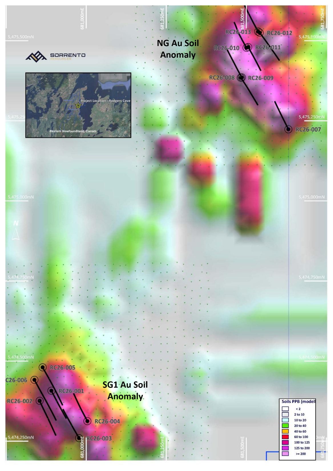
Sorrento completed the first drill program at Rodgers Cove in 2026, with assays reported for all 13 holes. The program tested the SG1 and NG soil anomalies; holes RC26-007 through RC26-013 tested NG, approximately 1–1.5 km from the previously reported holes.

Select any map or section to enlarge it.

Plan map of all 13 Rodgers Cove drill holes over the SG1 and NG gold-in-soil anomalies
All 13 completed drill-hole collars over the modelled gold-in-soil anomalies at SG1 and NG, from the August 6, 2026 results release.

RC26-003 · SG1

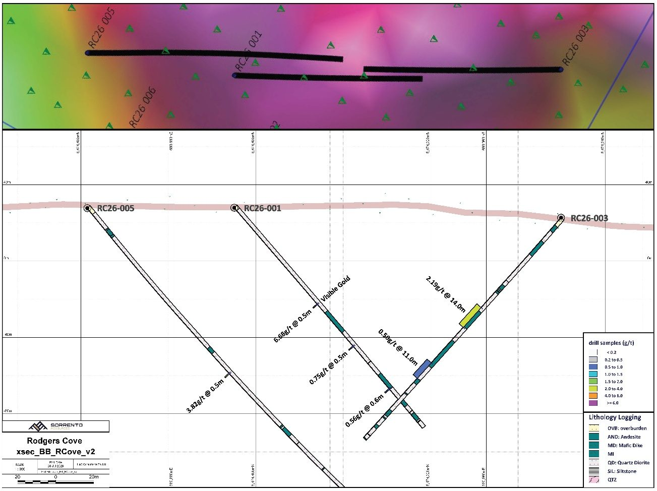
14 m at 2.19 g/t Au

From 63 m downhole, including 8 m of 3.17 g/t Au and 1 m of 10.87 g/t Au.

RC26-010 · NG

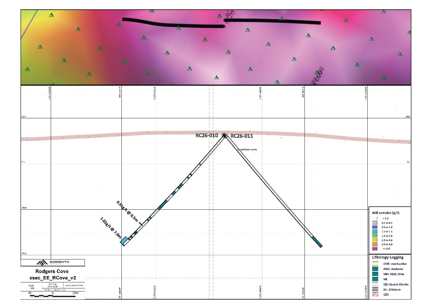
31 m at 0.42 g/t Au

From 100 m downhole, including 7 m of 1.01 g/t Au from 124 m. The hole ended in mineralization.

RC26-007 · NG

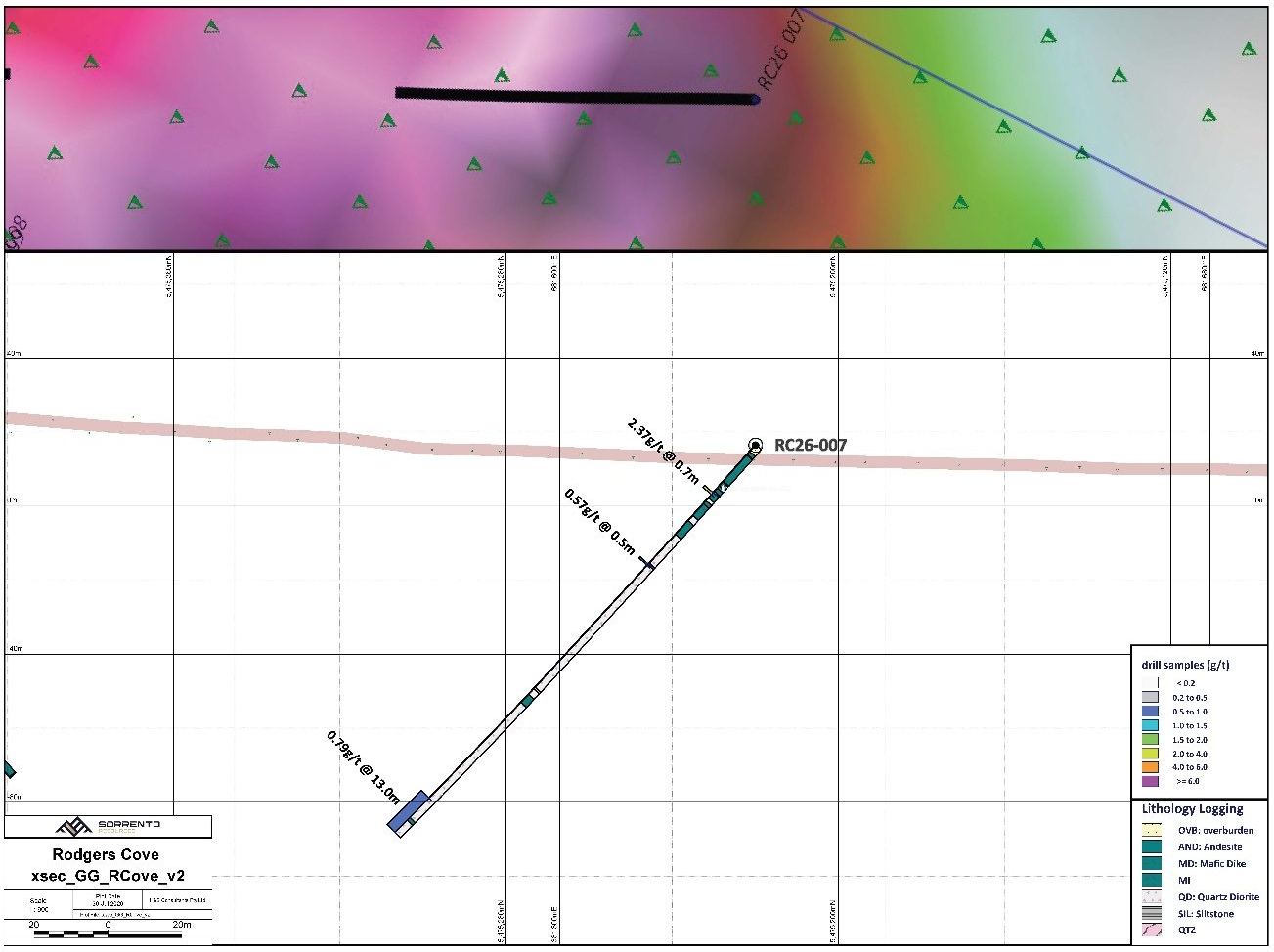
13 m at 0.79 g/t Au

From 130 m downhole, including 4.6 m of 1.28 g/t Au. The hole ended in mineralization.

Intervals are reported as core lengths. Current data are insufficient to determine true widths. Results are preliminary and insufficient to define a mineral resource.

Rodgers Cove B–B′ cross-section through RC26-001, RC26-003 and RC26-005 with gold assays and lithologies
Section B–B′ shows the lithologies and gold assays in RC26-001, RC26-003 and RC26-005, including RC26-003's 14 m interval grading 2.19 g/t Au from 63 m.
Rodgers Cove E–E′ cross-section through NG drill holes RC26-010 and RC26-011
Section E–E′ shows RC26-010 and RC26-011 at NG. RC26-010 returned 31 m of 0.42 g/t Au from 100 m, including 7 m of 1.01 g/t Au from 124 m, and ended in mineralization.
Rodgers Cove G–G′ cross-section showing RC26-007 gold assays, lithologies and mineralization at the bottom of the hole
Section G–G′ shows RC26-007 at NG, including 13 m of 0.79 g/t Au from 130 m. The hole ended in mineralization, leaving the mineralized zone open at depth.

All section intervals are core lengths; true widths remain undetermined. Technical information in the June 2 and August 6, 2026 news releases was reviewed and approved by Dr. Derek Wilton, an independent Qualified Person under National Instrument 43-101.

Geology & Soil Targets

Rodgers Cove is situated on the eastern edge of the Dunnage Zone within the Exploits Subzone. The property straddles the Appleton and JBP Faults. The 2026 drilling identified gold mineralization primarily in altered mafic dykes within quartz diorite; locally, gold and sulphides also occur in quartz veins and in the quartz diorite groundmass.

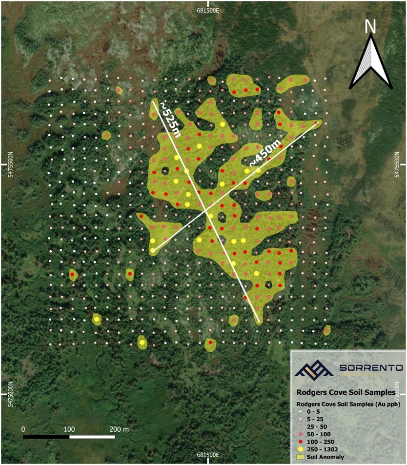
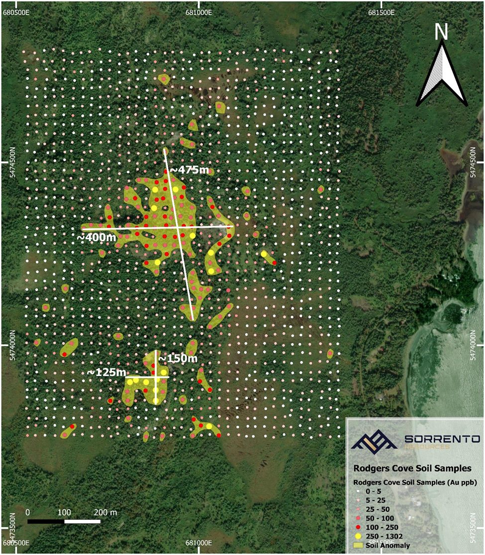
The 2025 soil program collected 2,405 samples across four grids. Results announced on March 4, 2026 outlined three coherent gold-in-soil anomalies: NG (525 m × 450 m), SG1 (400 m × 475 m) and SG2 (125 m × 150 m).

The NG and SG1 anomalies provided the geographic framework for the first drill program. The maps below show the soil sample locations and anomaly footprints, complementing the completed drill-hole plan above.

North Grid gold-in-soil sample map showing the 525 by 450 metre NG anomaly
North Grid soil sample locations and the approximately 525 m × 450 m NG anomaly, reported March 4, 2026. Holes RC26-007 through RC26-013 subsequently tested NG.
South Grid gold-in-soil sample map showing the SG1 and SG2 anomaly footprints
South Grid soil sample locations showing the approximately 400 m × 475 m SG1 anomaly and 125 m × 150 m SG2 anomaly, reported March 4, 2026.

Technical information in the March 4, 2026 soil-results release was reviewed and approved by Alex Bugden, P.Geo., a Qualified Person under National Instrument 43-101. Soil anomalies are exploration targets.

Historical exploration background

Before Sorrento's 2026 program, Rodgers Cove had seen limited historical exploration and had never been drilled. Historical soil geochemistry, trenching and limited channel sampling identified the numbered targets shown on this earlier map.

  • Target #1: 800 × 600 m soil anomaly with up to 758 ppb Au; trench results up to 115.6 g/t Au over 1 m.
  • Target #2: 400 × 500 m anomaly with soils between 50–300 ppb Au; historical showings up to 14.56 g/t Au and 440 g/t Ag.
  • Target #3: 100 × 450 m anomaly with soils up to 1.78 g/t Au.
  • Target #4: Gold showings including Rodgers Cove (7.55 g/t Au), Kypher (11.93 g/t Au) and Long Pond (7.16 g/t Au).

Sorrento has not verified the historical work. Grab samples are selective and may not represent overall mineralization. These historical numbered targets are distinct from the NG, SG1 and SG2 anomalies reported from Sorrento's 2025 soil program.

Historical Rodgers Cove numbered exploration targets map
Historical numbered exploration targets at Rodgers Cove, retained as background to the current soil and drilling maps.

Next Steps

Mineralization remains open along strike and up and down dip. RC26-007 and RC26-010 both ended in mineralization, providing a basis for follow-up exploration at NG alongside the mineralization identified at SG1.

Further drilling is required to determine the continuity, geometry and grade distribution of mineralization. The completed drilling and soil results provide the framework for advancing the Company's understanding of the Rodgers Cove system.

Join Our Mailing List

Sign up to receive updates on our latest news and events. Your email will never be shared or sold and you can opt out at any time.

No, I don't want to receive updates

Thank you for subscribing!

We'll send you updates on our latest news and events.

Close